The 2015 QR X350, looking like a NASA Spaceship, isn't only built to excite, but has a sensible blend
of features, safety and value, to make it a compelling choice for all quadcopter
pilots. We have provided a quick translation of the specification of the new 350 size quadcopter,
the first of the
iUAS 2015 series and an inside look into some
of new enhancements planned for.
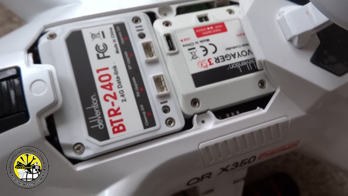
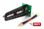
What differentiates this model to it's predecessor is the
introduction of the dual GPS System for failover. Leveraging both GPS/GLONASS
satellite systems, by connecting a second GPS, this allows us to overcome GPS
glitches. It has been documented that
even with two identical GPS modules, it is quite common for one of the GPS
modules to deviate with errors during flight. The programming logic currently switches between the two GPS modules based on the lock status and
number of satellites.
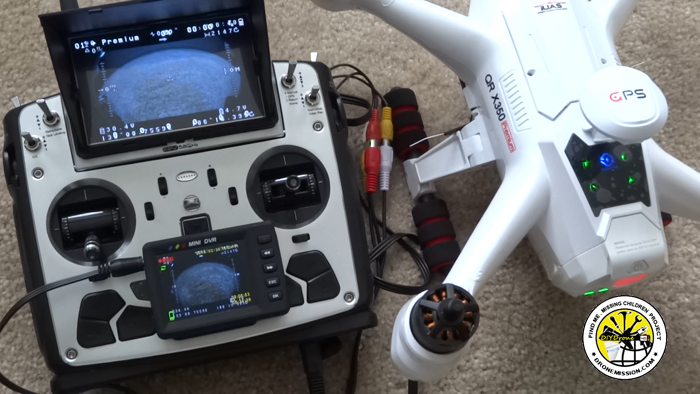
Piloting with an On Screen Display (OSD) has always been an
advantage when flying long distance; this brings us to the second major
enhancement to
this quadcopter, a pilot's HUD. The OSD will display various critical
flight information on your LCD screen, goggle, monitors or even flat screen TV
with a video receiver. In terms of safety and smart piloting, the OSD will
communicate the health of the UAV, feeding you the number of satellites, sending
warning messages, calculating battery consumption and helping you fly by compass
manually, in the event GPS is an issue. Best of all, you will also know
which flight mode you are in, if you are in control or are you in failsafe or
autopilot mode. This will help you make better in-flight decisions as a
pilot.
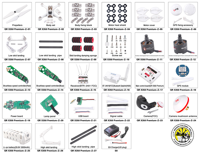
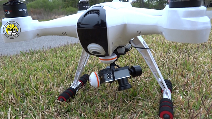
Lastly, a move towards an integrated camera. The x350
Premium will have a 1080p HD camera with wide-angle lens for FPV. With the base
of the quadcopter free from a gimbal, we may just be able to install a drop box
below (example a SAR GPS
Locator Drop, or candy drop or a first-aid drop). Walkera continues to improve on the Ground Station Controls for
phone and tablet. The Flight Controller supports most of the APM Copter flight modes. The
x350 Premium is intended to be RTF, but for the DIY hobbyist, this platform
continues to serve as a great choice where you can continue to enhance the model
with various new components and development from the dronecode.org projects.
Featured in Episode 91
Where to:
US$999 www.ucdrone.com
(just click on links will support DM)
Tips:
The x350 Premium uses a DATA BUS, which makes it easy to assign switches.
If you plan to land with GPS Mode (Position 1), remember to lower
your throttle to zero, switch to Manual (Position 0) 6 inches above ground, just
upon touchdown. The copter will try to find ground but may not always be
perfect on not so level ground or a mole hill. Due to extreme vibrations,
during landing and hitting the ground, the copter can at times actually
thought it was flying again. The inertial system is unavailable with those
vibration levels. Striking a balance in safety and intelligence, the system will
not disarm in GPS modes while it thinks it is flying, a preventive measure.
The outcome, your copter will topper over while you try to land and disarm in
GPS mode. The propellers could have been stopped very quickly by changing to
Manual mode and disarming. It always accepts disarm commands in Manual
(Stabilize) and Acro modes. This applies to all APM copters and not
limited to the x350 premium.
1. 双GPS系统给飞行提供信号保障
Dual GPS
System. High performance GPS/GLONASS
provides redundancy and accuracy in
autopilot.
2.内置OSD,可精准计算Home
Arrrw,飞行速度,飞行时间,GPS,经纬度,电池电压等功能
HUD Technology
On Screen Display showing Home Direction,
Compass Rose, Flight Mode, Flight Speed,
Flight Duration, GPS Coordinates, Battery
Voltage and other functions
3.
实现系统故障自我检测功能,可以自我检测飞行器的接收器,GPS信号,罗盘,气压计和电池电量;System
self-diagnostic. Prearm safety checks on
receiver, GPS signals , compass , barometer
and battery.
4.内置地面站控制系统,用手机平板飞行可自由切换控制模式,也可通过手机或平板设定各项参数
Ground Station Control System. Using a
mobile phone or tablet, you can change
flight modes and set waypoints.
5.标配HD鱼眼相机
Equipped with
HD wide-angle lens camera for aerial
photography.
6.搭配12通道FPV遥控器DEVO
F12E实时监控飞行器电池电压、高度、距离,飞行速度,飞行时间,GPS,经纬度 等参数
First Person View (FPV) with a professional
12-channel radio, real-time telemetry
monitoring aircraft battery voltage, height
, distance, flight speed, flight time , GPS
coordinates.
7. 飞行时间Flight
Duration: 20-25
minutes
8. Radio Transmitter Control Range: 1km
9. Video Range: 500-800m
(FCC)
Key Features
1. 360° Auto Rotation Circle
Mode
2. Follow Me Mode
3. One Key to Start (Auto take off)
4. One key to go home
5. Failsafe returns and lands
6. 预留支持G-2D、G-3D、G-3DH,
G-3S云台,
Supports G-2D, G-3D, G-3DH,G-3S gimbal.
7. Supports Waypoint flying mode
8.
可查看飞行器已飞行时间
Monitor Flight Time, On Screen Display for
long distance piloting
Trivia If you are
wondering who is iUAS. iUAS Inc located in Seattle WA, is a Walkera company that designs and
manufactures advance technology products for unmanned aircraft systems since
1994... and iUAS is run by an all female executive team.
www.ucdrone.com

 Piloting with an On Screen Display (OSD) has always been an
advantage when flying long distance; this brings us to the second major
enhancement to
this quadcopter, a pilot's HUD. The OSD will display various critical
flight information on your LCD screen, goggle, monitors or even flat screen TV
with a video receiver. In terms of safety and smart piloting, the OSD will
communicate the health of the UAV, feeding you the number of satellites, sending
warning messages, calculating battery consumption and helping you fly by compass
manually, in the event GPS is an issue. Best of all, you will also know
which flight mode you are in, if you are in control or are you in failsafe or
autopilot mode. This will help you make better in-flight decisions as a
pilot.
Piloting with an On Screen Display (OSD) has always been an
advantage when flying long distance; this brings us to the second major
enhancement to
this quadcopter, a pilot's HUD. The OSD will display various critical
flight information on your LCD screen, goggle, monitors or even flat screen TV
with a video receiver. In terms of safety and smart piloting, the OSD will
communicate the health of the UAV, feeding you the number of satellites, sending
warning messages, calculating battery consumption and helping you fly by compass
manually, in the event GPS is an issue. Best of all, you will also know
which flight mode you are in, if you are in control or are you in failsafe or
autopilot mode. This will help you make better in-flight decisions as a
pilot.

 Tips:
The x350 Premium uses a DATA BUS, which makes it easy to assign switches.
Tips:
The x350 Premium uses a DATA BUS, which makes it easy to assign switches.