Missions and Press Updates
There are currently no active search missions or for privacy / regulations they
will not be included.
For our complete services, please visit SERVICES |
 |
Drone Mission Drills
- Scorecard : This is a drill that usually involves 3 or more SAR volunteers. The scout plane will be sent out to search,
upon identifying points of interest (POI), the Pilot and Sensor Operator will call
out GPS coordinates on scorecards. The Spotter will also assists in
keeping track of flight time, weather conditions and temperature which can
potentially be used as evidence too. The scorecards are handed over to
the multirotor pilot to setup waypoints for autonomous flight and to locate
the same exact GPS location as written on the scorecard. Upon successful
completion, scorecards can be handed out to the Analyst and ground search teams.
Analysts continuously review feeds and HD footages.
- Reality Capture : reality capture is in 3D. the SAR multi-rotor
pilot flies to a subject and film it around 360 degrees (circle mode) and aerial, and the
video is used to create a 3d model on computer. The 3d model can be use as
evidence, as it is a reality model. The old way, you build a model to
reconstruct a scene; now we do the reverse, we build a model from real data
collected. This, we call reality capture.
- GPS Drop : A drop is basically to drop a GPS tracker at a point of
interest for the ground search team to locate. A GPS tracker is placed
in a soft impact ball, dropped from a plane or multirotor, 30 feet south or
before the POI. The GPS
tracker will send sms text messages with the GPS coordinates to the ground
crew.
SAR Team
- Pilot : Main responsibility is to pilot the aircrafts
- Sensor Operator: Perform surveillance & assessment,
operate cameras, sensors and
backup pilot
- Spotter: Monitor environment, surrounding and time
- Analyst: Review feed and HD footages, co-ordinate with various
teams.
Featured Search Updates
|
|
Search & Rescue Services
Searches and rescues are provided by volunteers and sponsored by corporations
and conducted along with other SAR organizations. There is
no cost when volunteers offer their services. Since 2007, with the exception of recreational flights, we have to ask the FAA for a certificate of authorization
(COA) with good reasons for emergency flights out of sight. All law
enforcement agencies can request for COA and we can assist in processing the
request.
We assist in missing persons searches and support ground search teams,
providing the GPS coordinates of any point of interests.
How it works:
Alerts are broadcast to our list of volunteers. A SAR volunteer will
evaluate each request and make the necessary arrangements with authorities for
the mission.
The requester will be the Point of Contact (POC). The POC and alternate POC you
nominate will meet with the mission
planner to discuss the details. Initial way points will be determined on
maps and dispatch to the volunteer pilots. The pilots will attend a mission
brief. Each mission flown will usually be coordinated with a
ground search team on site. All necessary COA will be completed before the
missions.
SAR Depot
Our SAR Depot provides loan free models to SAR
organizations on a search mission. Currently these fleets are station in
Florida.
 DM
Rescue P1-Catalina, 15 minutes, GPS, 720P DVR, Boscam Freq. DM
Rescue P1-Catalina, 15 minutes, GPS, 720P DVR, Boscam Freq.
Location: Hangar 3 |
 DM
Rescue P2-Bix, 20 minutes, APM GPS,
720P DVR, Boscam Freq DM
Rescue P2-Bix, 20 minutes, APM GPS,
720P DVR, Boscam FreqLocation:
Hangar 1 |
 DM
Rescue M3-Tali, 25 minutes, GPS, 1080P
DVR, Fatshark Freq. DM
Rescue M3-Tali, 25 minutes, GPS, 1080P
DVR, Fatshark Freq.Location: Hangar
3 |
 DM
Rescue M4-Tali, 25 minutes, GPS, 1080P
DVR, Fatshark Freq. DM
Rescue M4-Tali, 25 minutes, GPS, 1080P
DVR, Fatshark Freq.Location: Hangar
3 |
 DM Rescue
M1-Apache. 10 minutes, 720P, DVR,
APM GPS, Fatshark Freq. DM Rescue
M1-Apache. 10 minutes, 720P, DVR,
APM GPS, Fatshark Freq.Location:
Hangar 1 |
 DM Rescue
M6-QR800. GPS 40 minutes, 1080P
DVR DM Rescue
M6-QR800. GPS 40 minutes, 1080P
DVRLocation: Hangar 3 |
 DM
Rescue M7-Tali, 25 minutes, GPS, 1080P
DVR, Fatshark Freq. DM
Rescue M7-Tali, 25 minutes, GPS, 1080P
DVR, Fatshark Freq.Location: Hangar
2 |
 DM
Rescue M8-Tali, 25 minutes, GPS, 1080P
DVR, Fatshark Freq. DM
Rescue M8-Tali, 25 minutes, GPS, 1080P
DVR, Fatshark Freq.Location: Hangar
2 |
 DM Rescue
M5-350P. 20 minutes, GPS, 1080P DVR,
Fatshark Freq. DM Rescue
M5-350P. 20 minutes, GPS, 1080P DVR,
Fatshark Freq.DM M2. Decommissioned |
 DM
Rescue M9-Scout, 20 minutes,
GPS, 1080P DVR, Fatshark Freq. DM
Rescue M9-Scout, 20 minutes,
GPS, 1080P DVR, Fatshark Freq.
Location: Hangar 2 |
 DM
Rescue M10-Scout, 20 minutes, GPS,
1080P DVR, Fatshark Freq. DM
Rescue M10-Scout, 20 minutes, GPS,
1080P DVR, Fatshark Freq.Location:
Hangar 1 |
DM
Rescue M11-Scout, 20 minutes, GPS,
1080P DVR, Fatshark Freq.
Location: Hangar 3
|
 DM
Rescue P3-Eyes, 20 minutes, GPS, 720P DVR, Boscam Freq. DM
Rescue P3-Eyes, 20 minutes, GPS, 720P DVR, Boscam Freq.Location: Hangar 1 |
DM Rescue
M6-350P. 20 minutes, GPS, 1080P DVR,
Fatshark Freq. Location:
Hangar 3
|
|
DM Rescue
M12-350P. 20 minutes, GPS, 1080P DVR,
Fatshark Freq. Location:
Hangar 3
|
DM Rescue
M13-350P. 20 minutes, GPS, 1080P DVR,
Fatshark Freq. Location:
Hangar 3
|
-
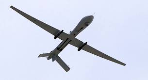
DM Rescue P3 Eyes : is a plane used
for search and rescue missions. The
distance control range is up to 1.5 miles
and can fly a total of 30 minutes, glides
without any power along with the wind. It
is equipped with a FPV backpack, Onboard
DVR records footage in HD. Includes a GPS
and can return home and auto land. It can
fly waypoint missions, OSD provides flight
data and is recorded on a ground
station DVR, developed by Feiyu Tech.
Donated by Banggood.
- DM Rescue P2 Bix : is a plane used as a
front scout to survey a site to determine
way points for search and rescue. The
distance control range is up to 1.5 miles
and can fly a total of 20 minutes, glides
without any power along with the wind. It
is equipped with a FPV backpack, a GPS and
can return home and auto land. Onboard DVR
records footage in HD. Donated by iUAS
- DM Rescue M1 Apache: is a quadcopter used as
a front scout to survey a site to
determine way points for search and
rescue. The distance control range is up
to 1.5 miles and can fly a total of 10
minutes. It is equipped with a FPV
backpack, 1-axis gimbal camera stabilizer,
a GPS and can return home and auto land.
It can fly waypoint missions, OSD provides
flight data and is recorded on a DVR,
developed by 3DR Arducopter
- DM Rescue M2 QR350: is a quadcopter used for
search and rescue with 1080p HD. The
distance control range is up to 1 mile and
can fly a total of 20 minutes. It is
equipped with a 2-axis gimbal and FPV
camera, a GPS and can return home and auto
land. It can fly waypoint missions,
developed by iUAS.
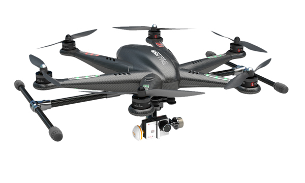
- DM Rescue M3 Tali: is a hexcopter used for
search and rescue with 1080p HD. The
distance control range is up to 1.5 miles
and can fly a total of 20 minutes. It is
equipped with a 3-axis gimbal and FPV
camera, a GPS and can return home and auto
land. It can fly waypoint missions,
OSD provides flight data and is recorded
on a DVR, developed by iUAS.
- DM
Trainer M5 350: 1 short mission quadcopter for
training, 10 minutes flight time
- DM Rescue M6
QR800: long mission GPS 40 minutes
Other Equipment
- 4 FPV/VideoTX/DVR Camera Backpack
Ready
- 1 Netbook
with Mission Planner
|
Drone Mission
Saturday April 02, 2016
Education | Projects
| Services |
Missions |
Home
 |